Wellness
Munich's Top Walking Trails Rated by Distance and Difficulty
From flat riverside loops to punishing hillside climbs, the city's green corridors offer something for every fitness level — here's how they stack up.
4 min read
Updated 3 h ago
Wellness
From flat riverside loops to punishing hillside climbs, the city's green corridors offer something for every fitness level — here's how they stack up.
4 min read
Updated 3 h ago
Munich's parks are full. On any given weekday morning in July, the Englischer Garten alone draws thousands of walkers, joggers and Nordic-pole enthusiasts before 9 a.m. The city's outdoor fitness culture has been building for years, but sport science researchers at the Technische Universität München reported in early 2026 that habitual outdoor walking in urban green spaces reduced self-reported stress markers by 23 percent among regular participants — a figure that is now circulating widely among Munich's community health networks. Put simply, the trails matter, and knowing which one to pick matters more.
Germany's ongoing push to cut cardiovascular disease burden — the Robert Koch Institut projected in 2025 that sedentary behaviour costs the national health system roughly €14 billion annually — has accelerated municipal investment in accessible outdoor routes. Munich's city council allocated €3.2 million in the 2026 budget for trail maintenance, signage upgrades and new fitness stations across twelve green zones. That spending is now visible on the ground.
Start simple. The Isarufer path running along the east bank between the Deutsches Museum and the Maximiliansbrücke covers roughly 3.5 kilometres on almost entirely flat tarmac and compacted gravel. Difficulty: low. The route crosses no significant gradient, passes drinking fountains at two points near the Museumsinsel, and connects easily to the U-Bahn at Fraunhoferstraße for anyone who wants a one-way walk rather than a loop. It is the city's most forgiving long trail for people returning from injury or those new to regular walking.
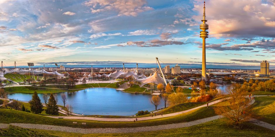
The Olympiapark circuit is another beginner staple. The outer perimeter path around the Olympiasee clocks in at 4.2 kilometres. The terrain is gentle with one short rise toward the Olympiaberg — a 52-metre-high hill built from Second World War rubble — which qualifies as the hardest section and still takes less than four minutes to climb. The park is managed by Olympiapark München GmbH, which updated the trail markers and installed three new fitness stations along the western path in March 2026. Entry to the park grounds remains free.
The Forstenrieder Park in the city's southwest is a different proposition. This ancient state forest covers 1,600 hectares and the main marked circuit — starting from the car park on Forstenrieder Allee — runs 9.8 kilometres with modest but cumulative elevation changes through dense mixed woodland. Difficulty: moderate. The surface switches between forest track and occasional muddy sections after rain, so trail shoes are worth the investment. The Bavarian State Forestry Office (Bayerische Staatsforsten) maintains the route and posts seasonal condition updates at the Forstenried information board near the Buchendorf entrance.
For the genuinely demanding option without leaving Munich's greater metro area, the Perlacher Forst combined with the climb up to the Aussichtspunkt at Grünwalder Forst offers 14 kilometres of varied terrain. Walkers log around 280 metres of total elevation gain across the full route. This is the trail that Munich's running clubs — including the active Lauftreff communities registered with the Münchner Turn- und Sportverein 1879 — use for weekend endurance sessions. It demands proper footwear and at least two litres of water in July heat.
One number to keep in mind: the German Weather Service (Deutscher Wetterdienst) has forecast mean July temperatures for Munich at 27–30°C through mid-month, several degrees above the long-term average. That makes start time critical. The city's sports medicine advisory service at the Städtisches Klinikum München recommends hitting any trail over 8 kilometres before 8 a.m. or after 6 p.m. during heatwave conditions.
Pick your trail, check the DWD forecast the night before, and carry a paper map as backup — mobile signal drops in both Forstenrieder Park and the Perlacher Forst. Munich's green infrastructure is genuinely world-class. Using it intelligently is the only skill required.
About this article
Published by The Daily Munich
Spread the word
Daily brief
Free, in your inbox before 7am. Weekdays.
The Daily Network — local news across Australia